During a Disaster
In the event of a disaster or emergency, you need to stay calm, follow your prepared emergency plans and, if possible, tune into a local ABC or commercial radio station to stay informed and follow instructions from authorities promptly.
Make sure you remember to:
- Check weather updates and if local roads are closed.
- Check on neighbours and people who may need your assistance. Think about the needs of your animals (pets) and where you will take them.
- Check that your drinking water is not contaminated.
In the event of a Bushfire
Prepare yourself
Prepare your property
- Make sure your property has cleared access for fire trucks
- Cut back overhanging trees
- Rake up leaves, twigs and branches
- Cut grass regularly, keeping it as short as possible
- Clear leaves from your roof, gutters and downpipes
- Do not pile-up wood or store green waste close to your house
- Clear space around buildings
- Keep your garden hose connected and ready to use
- Ensure your garden hose can reach every corner of your property
- Be mindful of the location of your gas cylinders. Make sure pressure valves face away from your house
- Fill in any gaps around windows, door frames and eaves
Prepare to Leave
If you plan to leave - do so early - before a fire reaches your area
- Advise family members, neighbours or other loved ones if you have left
- Listen to ABC 1566AM, 1071AM, 88FM, 89.1FM, 90.7FM, 96.3 for information and advice
- Refer to the Queenland Fire & Emergency Services (QFES) website for more information about current incidents
- Locate your Bushfire Survival Kit
- Activate your Bushfire Survival Plan and follow it
Declared Fire Danger Period
Queensland Fire & Emergency Services can declare a Fire Danger Period. A Fire Danger Period identifies a time of the year when uncontrolled fires could be potentially very dangerous.
It is important to note that a Fire Danger Period is not a fire ban. A fire ban may still be imposed during a Fire Danger Period.
Fire Bans
Queensland Fire & Emergency Services has the authority to declare a fire ban which restricts the use of fire. When a fire ban is in place:
- the lighting of fires in the declared fire ban areas (usually covers whole local government areas) is prohibited
- all open fires are prohibited
- all Permits to Light Fire issued in the designated area are cancelled
- other special conditions (or exemptions) may be imposed.
You should always check if a Fire Ban has been implemented prior to lighting any fires.
Information about Fire Bans is available at Rural Fire Service website or by contacting 1800 020 440.
Smoke Hazards
Extra care should be taken when driving in areas affected by smoke and or fire.
Check road conditions and listen to local radio stations ABC 1566AM, 1071AM, 88FM, 89.1CFM, 90.7FM, 96.3 for additional information.
Children, the elderly, and people with asthma and other breathing problems may need to take particular care during the bushfire season. Further information available at the Asthma Foundation.
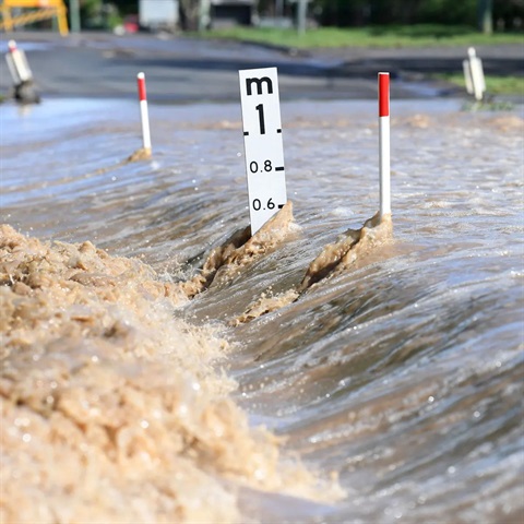
In the event of a Flood
Visit Council's Disaster Dashboard for the current road closures due to flooding for the Western Downs Regional Council. Please note conditions can change without warning.
Never enter flood waters. This means on foot, rubber dingy, body board or in your vehicle. If it’s flooded – forget it. Flood waters include roads, causeways and creeks, etc.
Drivers are urged to:
- Drive to the conditions of the road
- Err on the side of caution
- Never attempt to drive across or through flooded bridges, roads or flood ways
- If leaving home in this weather, make sure someone knows your movements and time frames
- Be mindful that potholes and pavement failures may be present and concealed under flood waters or camouflaged by reflections off the water surface at night, ie everything looks black.
Prepare to Leave
If you plan to leave - do so early - before flooding affects your ability to.
- Advise family members, neighbours or other loved ones if you have left
- Listen to ABC 1566AM, 1071AM, 88FM, 89.1FM, 90.7FM, 96.3 for information and advice
- Refer to the Bureau of Meteorology (BOM) website for more information about weather updates
Further Information
INTERIM FLOODPLAIN ASSESSMENT OVERLAY
The Premier has recently launched an Interim Floodplain Assessment Overlay Map (Floodplain maps) which can be accessed via the Queensland Reconstruction Authority website. The Floodplain mapping show areas of Queensland where, based on geological evidence, it is known that there has previously been inundation or there is a probable chance of inundation.
The Floodplain maps are supported by the 'Planning for Stronger, More Resilient Floodplains Guideline' and have been derived from overlaying available state-wide information sources, including best available:
- Drainage location information
- Contour information (typically 10-metre contours)
- Satellite imagery (typically Landsat 5)
- Interpreted or actual flood information from 2010/2011 events
- Department of Environment and Resource Management gauging station information
- Pre-clear Vegetation Mapping of Land zone 3 (Alluvium) and Land zone 1 Estuarine and SALI Soil Flooding Limitation Mapping
Given the size of Queensland, there are areas where the mapping is still being produced. The Queensland Reconstruction Authority has established a programme to develop the floodplain maps for the entire State and release them as they become available.
The interactive map also shows Interim Flood Lines for towns and cities affected by flooding in 2010/11. The Interim Flood Line has been mapped using ultra-high resolution aerial photographs (where available), in combination with Council and community feedback.
Evacuation
Evacuation is the planned movement of people from an unsafe or potentially unsafe location to a safer location. They will be returned once the emergency is passed. When evacuations are necessary, you will be told through the media or by other warning methods. In the event of an evacuation, Council will open centres relevant to the location of the disaster as a place of refuge for residents who are voluntarily looking to leave their homes.
Emergencies
If the situation is life threatening, always call Triple Zero (000).
For SES emergency assistance, contact SES 132 500 from anywhere in Queensland for non-life threatening flood and storm emergency assistance during severe weather events.
To report a Council-related incident or emergency, call 1300 COUNCIL (1300 268 624).
Stay Informed
Local Road Closures
The Western Downs Disaster Dashboard provides all the latest information on current disasters including emergency news along with road closure notifications.
View the Disaster Dashboard.
Queensland Road Closures
131 940 aims to be a one stop shop for traveler in Queensland where they can find accurate and up-to-date information on road closures. To view road closures Queensland-wide, visit www.qldtraffic.qld.gov.au.